Rediscovering Camp Discharge
Visiting the Site
The Camp Discharge location is privately owned and off limits to the general
public — except for a lone, legal avenue of access for the hiker, the
Sid Thayer trail, a blazed footpath (0.9 miles one way) that is part of Lower
Merion Township’s Bridlewild Trail system.
The walk offers views of the Schuylkill River (and Expressway) and takes you
into a corner of Lower Merion where remnants of our 18th and 19th-century
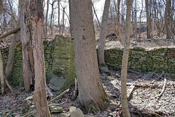
farming heritage persist. You will see several dry stone walls that demarcate
170-year-old property lines and the remains of Joseph Kirkner’s farmhouse,
barn and springhouse that predate Camp Discharge.
Camp perimeter
Parade ground
Sid Thayer
trail (public access)
farm lane and building ruins

audio description location
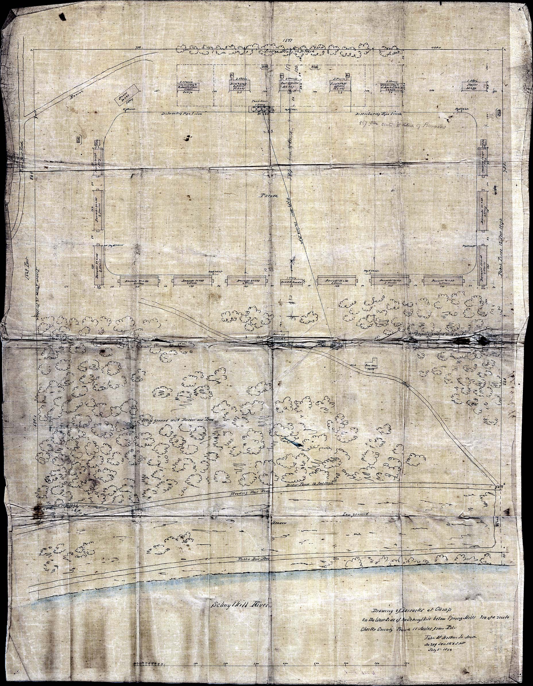
The Camp perimeter and parade ground are based on locations and
measurements in the
1864 architect’s plan.
 .
.
Our trail description starts from
Riverbend Environmental Education Center, at the eastern end of Spring Mill Road in Gladwyne.
-
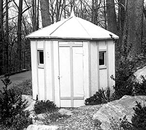
From Riverbend’s parking lot, look uphill to spot the last remaining Camp
Discharge structure, a small wooden sentry box. It was moved to this
location by the Wood family from the Camp’s Reading railroad gate.Downhill and across the street is the entrance to the Sid Thayer Trail,
marked with a sign. The trail curves across the wooded hillside as it
heads south, paralleling the Schuylkill River below, and a 19th-century
stone wall above. -
Pass through a grove of bamboo, cross a wooden footbridge, and you have
reached the camp’s perimeter. In 1864-65 it was marked by a 12-foot high
picket fence.Soon thereafter, another path merges from the right side. According to the
architect’s plan, you would now be standing amongst the barracks that
enclosed a corner of the Parade grounds, once above you up the slope,
overlooked by an enormous flagpole.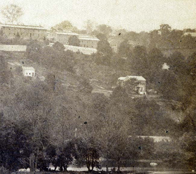
Top to bottom: barracks, farm buildings, railroad tracks, river.
Historical Society of Pennsylvania
-
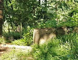
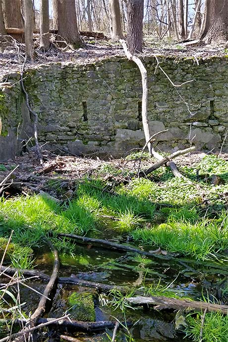
Less than 100 yards straight ahead, the tumble-down stones of Kirkner’s
barn and stable come into view on the left. The barn was enlarged by the
Wood family, who owned the Camp Discharge site from the 1880s to the
1960s, and quarried the area on the trail’s other side. Past the barn on
the left, a downhill fork switches back, following the 19th-century farm
lane, which once led all the way to the river road and train tracks, but
now is cut off by the Expressway. Beyond the barn you encounter the
springhouse which supplied the camp with water, then the farmhouse which
housed the camp commandant Col. John Hancock and his family.Author Jim Remsen describes the ruins in front of you and this spot in
1865 (2:09 audio).
Transcript
Notice the tumble-down foundation in front of you. It is all that
remains of a small stone barn built by the original white settler in
the early 1800s, and of a larger barn for horses that was built
alongside it in the 1950s. A few yards to the left of those ruins, and
also below you, is the rubble of the settlers’ old stone springhouse.
The Army hoped the water from this natural spring would meet the
camp’s needs, but it fell short and they had to pipe in creek water
from nearby. Farther down the hill is the foundation of the original
settler farmhouse. The commandant of Camp Discharge, Colonel John
Hancock, made this stone farmhouse his residence and actually brought
his wife and children to live there as well. Beneath all these ruins,
an old access road ran from the Reading Railroad stop up what was
called Break Neck Hill to the camp complex behind you, from lower left
to upper right. It would have been a busy byway for men and supplies
arriving and leaving on the daily train down below.Now turn around and face the uphill slope. A long line of imposing
two-story barracks buildings ran hundreds of yards across this rocky
slope, turned the corner at each end and continued up and over the
crest. The camp’s two hospital buildings were at the upper ends, while
the headquarters and supply buildings ran across the very top to
complete the square. In the middle of it all was a large and uneven
parade ground. Here and there was a network of latrines that served as
refuse pits and dumps. These latrines have yielded a number of
artifacts, from bullets to buttons to pig bones.If you are coming from the Riverbend parking lot, continue on the
trail and head uphill. At the top is another marker where you can hear
more about the camp. And be sure to stay on the trail at all times. -
Back on the main trail, as it curves uphill to the right, you enter onto
the camp’s Parade.The plans for Camp Discharge, dated July 5, 1864, were executed by
architect John McArthur Jr., who 7 years later designed Philadelphia City
Hall. McArthur’s plan covers almost the entire Kirkner property, which
bordered Lafayette road, edge to edge, from the stone walls on the hill
crest down to the Reading Railroad track.Further investigation may reveal how closely actual construction of the
camp matched the plan. If it did match, the parade stretched all the way
to present-day Martins Lane, and the hospital and barracks along its edge
lay on the location of #1709-1725, built in the early 1960s. 1724 Martin
Lane, at the end of the cul-de-sac, would correspond to the downslope line
of barracks.Listen to author Jim Remsen describe the 1865 view from the top of the
hill (1:20 audio).
Transcript
You are standing on the grounds of a nearly forgotten Civil War post.
Camp Discharge had a special mission: to handle stray Union soldiers,
all Pennsylvania volunteers, whose terms of duty were expiring. Many
were in bad shape from battle wounds or imprisonment. In fact,
virtually on this spot stood one of the two hospital buildings that
treated a constant caseload of men.You are standing at one side of a square-shaped complex of wooden
barracks, headquarters and supply buildings. As you face the
historical marker, imagine the buildings running downhill to the right
and into the woods, then turning left and continuing across for
several hundred yards, then turning back uphill in the distance. Off
to your left was the headquarters and the officers’ quarters. And in
the middle of this quadrant was a large, open parade ground where the
men would assemble for daily roll call. The parade ground featured two
ceremonial brass cannons, which boomed across the valley in April 1865
to celebrate the war’s end. It also featured an enormous flagpole
that, it is said, could be seen for miles around.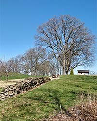
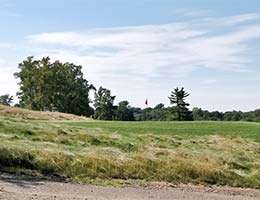
The trail merges with a service road. You can take the road to the right
to loop through the center of the parade, back to the fork described
earlier, with views over the golf course, fields and more stone boundary
walls. Straight ahead, the trail turns sharply left at Kirkner’s property
line and the camp’s western perimeter, still marked by the dry stone wall,
overgrown or buried in spots. It is a short walk down to Martins Lane,
where on-street parking is possible.
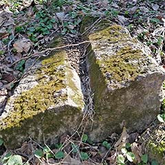
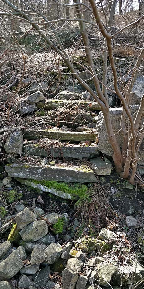
the trail, steps outside the farmhouse, back wall of the farmhouse.
Center: a cut stone gutter section
A Native Son’s Journey
Most people, even those living nearby, have no idea there was once a Civil War
post located here. But Brad Upp knew. During his boyhood in Gladwyne, he read
about the camp, hiked the area with his friends and vowed to learn more.
In the book Back From Battle, Brad tells the full, entertaining
story of his Camp Discharge journey. He moved away, became a Civil War
re-enactor and took up metal-detecting on Civil War sites, mostly in the
South. Back in Gladwyne, Brad began uncovering artifacts. His excitement grew
when he located images of the camp roster, and the singular old photo of the
camp itself, seen in its glory from across the river. Jerry Francis, president
of the Lower Merion Historical Society, helped him secure limited permission
from The Philadelphia Country Club, owner of the property, to continue
metal-detecting on the grounds. Even more relics emerged.
Partners in Research
Jerry saw the makings of an exciting project with much wider interest. He
reached out to Lower Merion resident Jim Remsen, a retired journalist who had
already researched and written
two books about other forgotten aspects of local history.
Jim and Brad plunged into a fruitful two-year research sojourn. They visited
archives in Philadelphia, Harrisburg, Wilmington, Norristown, Chester and
Washington, D.C. It proved an emotional experience, too, from the ecstatic
(uncovering blueprints of the camp and its buildings) to the sobering
(encountering the suffering and struggles revealed in military pension files).
Writing and Digging
One of Jim’s goals was to identify the Camp Discharge men who had survived
imprisonment at Confederate hands. By the time the book was published, Jim’s
POW list stood at 490 men, 44% of the 1,118 soldiers mustered out at Camp
Discharge. Brad and Jim investigated each of those 1,118, plus the 642 who
served at the camp as garrison guards. The
massive roster names and profiles each of those
men.
Jim pulled all their information together into a book-length narrative that
chronicles the camp, its men, and its place in military and local history.
Brad functioned as editor and fact-checker, and scoured the internet for
images of the Camp Discharge men. All the while, Brad continued his
excavations at the camp site—outings that continue to this day.
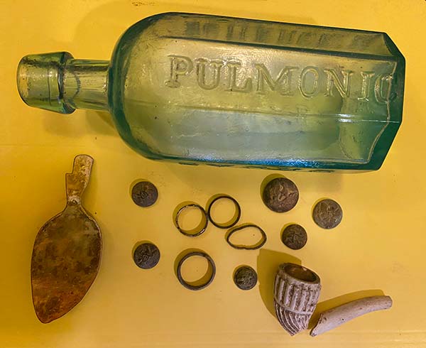
rings