One Rivers, Roads, Railroads, and Trolleys

Flat Rock Dam, Schuylkill River
For the Lenape and the early settlers, the rivers were the main mode of transportation and the seminal reason for the settlement of the area; the Schuylkill River runs from west to east for the entire length of the Township. Fisheries were located along the river where herring, bass, rockfish, pike, catfish and shad were plentiful. Located in the vicinity of Mill Creek, Flat Rock Dam and the adjoining canal locks were built in 1818 for use by the Schuylkill Canal, a transportation corridor that moved anthracite coal and other goods on barges from the Reading area into Philadelphia. The dam ruined the fishing, and also did away with the local fords that were used to traverse the Schuylkill River.

Levering Map of Lower Merion, 1851
Pictured is an adaptation of the 1851 map that was surveyed and drafted by John Howell Levering, and redrawn in 1908 by A.H. Mueller. Titled “Map of the Township of Lower Merion, Montgomery County, Pennsylvania. With all the divisions of property, the number of acres, and owners’ names, the names of villages, roads, streams, factories, hotels & etc. And a plan of the Borough of Manayunk,” this map is considered the first accurate, detailed map of Lower Merion. At this time, Lower Merion was a farming community and dependent on water-powered mills; therefore, Mr. Levering took great care in documenting the location of the various water sources. In addition to the river and the streams, the springs and wells were identified.

Conestoga Wagon
As Philadelphia continued to function as one of the nation’s major seaports, roads were built in order to move goods west to Pittsburgh. Our local roads, now known as Montgomery and Lancaster Avenues, were used as major arteries for the transport of settlers and goods mainly by Conestoga wagons. These were known as such because they were first manufactured in Conestoga, Pa. The person who wrote the handwritten message was moving west as well: “Am spending a few days in Denver. Lanc., PA, 11/19/07, Elmer.”

Montgomery Avenue, Bryn Mawr
Montgomery Avenue, because of its importance as one of the two major arteries in the areas, was the first road in the township to be macadamized and beautified. Tree-lined roads were indicative of the “progressive” transformation of the landscape from tree-less farmland to a manicured suburb. On another note, this postcard exemplifies how mail was used as a medium of communication at the time. The personal message reads “Don’t be so very much surprised if you receive a letter from me same day. Love to you. C.G.N. June 15, 1909.” Postage cost one cent, and there were two mail deliveries a day.

Along the Mill Creek, Bryn Mawr
This is an image of one of the two fords still in use in Lower Merion. The car was made locally in Ardmore by the Autocar Company. It is traveling down Old Gulph Road, crossing Mill Creek where it intersects with Youngs Ford Road. At this location, near the entrance to the ford, is Milestone #10, a colonial-era roadway marker with William Penn’s family’s coat-of-arms carved in the granite.

Lincoln Highway and Overbrook Presbyterian Church at City Limits
Lincoln Highway, or Lancaster Avenue (also known as US Route 30) is one of the longest routes in the United States. The car depicted is directed towards the intersection of City Line and Lincoln Highway, which continues west through the length of the township. Today it remains a busy intersection and an important link to Philadelphia. Additionally, the American flag flying at the top of the church’s steeple was not in the original photograph – it was painted on, perhaps to make the church look more “patriotic.” This was a common practice for colorized postcards.

Lincoln Highway at City Avenue
This is Lincoln Highway looking east, towards Philadelphia. One can see a Toll House on the right. Tollbooths were established along the township’s main roads – a total of nine “toll gates” were along this route.

Toll House at Lancaster and City Avenues
This is an early photo of the busy tollhouse at Lancaster Avenue (also known as Lincoln Highway) and City Avenue. Built in 1871, it operated until 1917, at which time the Commonwealth of Pennsylvania took control of Lancaster and Montgomery Avenues, and removed all local tollhouses. Pictured at the entryway is the caretaker – since collectors had to be on duty to collect tolls seven days a week, most tollhouses also functioned as family residences.

“Taking Toll” – Montgomery Avenue, Narberth
Both Lancaster and Montgomery Avenues were owned by the Philadelphia, Bala and Bryn Mawr Turnpike Company. Pictured is the tollbooth at Montgomery and Meeting House Lane, across from the Merion Meeting House. Message reads “Have a few cards for you already. The Kodak works fine. James Sadleir. June 7th.”

Pennsylvania Railroad Station, Merion Station
Less than a mile west of City Line, the first Pennsylvania Railroad (PRR) train station in Lower Merion is Merion Station. Made of brick and stucco, the surviving complex at Merion is one of the most complete examples of a typical early 20th century suburban PRR station in the region.

Pennsylvania Railroad: Pittsburg Express near Narberth
An important commuter and freight rail corridor, the PRR’s “Main Line” – now known as the SEPTA R5 – ran between Philadelphia and Pittsburgh. This steam train is traveling west from Merion Station and passing the signal tower on its approach to Narberth Station. This color image has a divided back and was published by the The Locomotive Publishing Company, London.

Pennsylvania Railroad Station, Narberth
Originally named “Elm,” the PRR renamed this station “Narberth,” meaning “sacred place” in Welsh, in an effort to gentrify the area. The Narberth station, located seven miles from center city, was one of the PRR’s stone-built Main Line structures, dating to the 1870s. It predated the establishment of the Borough of Narberth by over 20 years. The original stone structure was demolished in 1967. The personal message on the back reads: “We left home at 7 this morning and arrived at 1 o’clock traveled 100 miles it was a grand trip. We are going to Atlantic City on Monday some sports. Mrs. Watford. August 14, 1920.”

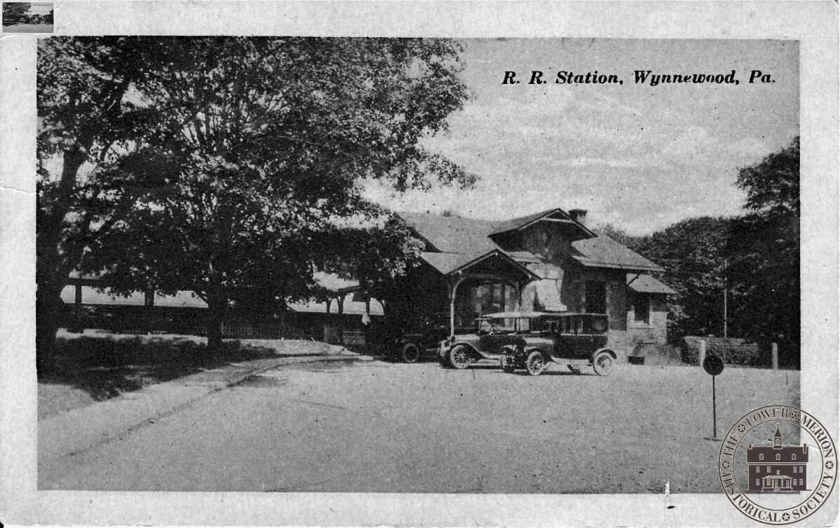
Pennsylvania Railroad Station, Wynnewood
Unlike the Narberth station, Wynnewood station still survives and is one of the best-preserved stone stations built by the PRR along the Main Line. The message on this postcard reads: “Thursday. Mr. H goes to Cleveland this week – wish I was going along. I am wondering if your radio works o.k. it should for we liked it so much over here. Guess we will have ours going again – its together then its not. – VaLH. November 6, 1924.”

Pennsylvania Railroad Station, Ardmore
This handsome station, constructed of native stone, was built in 1873 to serve the wealthy patrons of the Pennsylvania Railroad. By railroad standards, the trackside of the station (above) was the considered the “front,” and most important, side.

Waiting for the Train, Ardmore Station, Ardmore
(continued from previous caption) … Thus, images such as this one (below) that depicted the “back” of the building – where commuters arrive and depart from the platform area – are rare. By 1957, the depot had fallen into disrepair and was demolished and replaced by a one-story masonry box with an open area platform. Today, the station is the focus of the Ardmore Master Plan, which aims to set the stage for the redevelopment and economic revitalization of the neighborhood. These colorized images have a divided back and were printed in Germany. The speeding train in the top image was painted in, since moving trains were too difficult to capture sharply using the photographic equipment of the day.

Stadelman’s Pharmacy directly opposite the Ardmore Station
This so-called “postcard” was never meant to be mailed. On one side (top image) is a lovely Victorian engraving of the Ardmore train station. The other side advertised events, goods, and businesses in close proximity to the station. By coupling with pocket-sized train schedules, these cards also boasted an intrinsic practical value.

Stadelman’s Pharmacy
(see previous caption)

Pennsylvania Railroad Station, Haverford
This image shows the second station to serve Haverford, circa 1890, when the stop was still named “Haverford College,” after the nearby Quaker college. Also depicted are the striped awnings on the windows, which were standard accoutrement for many of the residential houses in the area.

Pennsylvania Railroad Station, Bryn Mawr – Trackside
This station was the jewel of the PRR’s crown of grand Main Line stations. The largest and busiest of the line’s depots, it was built in the Victorian style. It was torn down in the 1960s and replaced by a plain brick structure. The postcard was printed in Germany. The personal message reads: “This is a large and inspiring station. Have just come in from a walk and am virtuously preparing to study. Love Dale K. October 13, 1908.”

Pennsylvania Railroad Station, Bryn Mawr – Street Side
The street side of stations was considered the “rear” side, with the trackside being the front, and most important, side of the building. Built in the late 1800s, it served the only suburb that the PRR took a direct role in developing. Printed in Germany. The personal message reads: “Dearest Miss Mack. Thanks very much for your two nice card, you must be having a glorious time. We miss you very much. Mrs. Drexel is giving a party to-day and Tommy and I are going. Lovingly. Nancy. October 10, 1913.”

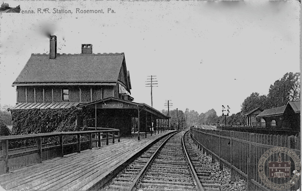
Pennsylvania Railroad Station, Rosemont
In 1863 Joshua Thomas donated land to the PRR for a passenger station to be named “Rosemont,” after his family estate. At the time, it was the furthest-west stop in Lower Merion. Now known as Ashbridge, the property has the township as its steward and is enjoyed as a public park.

Pennsylvania Railroad Station, Bala
In 1884, the profitable Pennsylvania Railroad, which had the leading service to the Midwest, tried to cash in on the anthracite industry by building a Schuylkill Valley Division that paralleled the Philadelphia and Reading Railroad into the coal regions of upstate Pennsylvania. The first station within the confines of Lower Merion on this Division was Bala, which was constructed at that location mainly for the convenience of Pennsylvania Railroad President George Brooke Roberts, who lived in nearby Pencoyd. The station, and surrounding area, was named after a small village in Wales, from which Mr. Roberts’ ancestors hailed. This neat frame structure was based on a standard design used by the railroad throughout its system. Until 1921, it also served as the local post office with Mary A. Riddle as Postmistress.

Pennsylvania Railroad Station, Cynwyd – Trackside
In 1890, the Pennsylvania Railroad built and named their new station Cynwyd, also after a village in Wales. At the time, the nearby village was known as Academyville, but the name of the community quickly changed to match the name of the station. This was a typical PRR depot: it incorporated passenger, freight, and postal services. In addition to the passenger shelter shed, this image depicts a couple of pieces of baggage on the freight ramp, waiting to be loaded. The personal message reads: “There is a dandy tunnel up here. Emma. September 20, 1910.”

Pennsylvania Railroad Station, Cynwyd – Street Side
The Adams Freight Company used these facilities, and they built a wooden frame addition on the station’s west side in 1910. It also served as the local post office for the village of Cynwyd until 1921, with Emma Riddle, Mary’s sister, as Postmistress.

Cynwyd – View from Station
One can see a train approaching Cynwyd in the distance; today, the station is the terminus on a regional rail line to and from center city Philadelphia. Cynwyd Station is the only surviving original Schuylkill Division depot in the area and is currently undergoing a “green” renovation. It will serve as the main trailhead for the Cynwyd Heritage Trail, which will follow the abandoned section of the rail line. Personal message reads: “Dear William: Can you see the train in this picture? Aunt Lucy and Uncle Frank used to live 2 blocks from the Station and he went to Phila on the train to his office to fix peoples’ teeth. Aunt Lucy sends love to you and everybody at home, so does, Grammies. Sunday Jan. 14, 1945.”
