Church of the Redeemer
230 Pennswood Road
Bryn Mawr, PA 19010
Church of the Redeemer website
Church of the Redeemer burial list
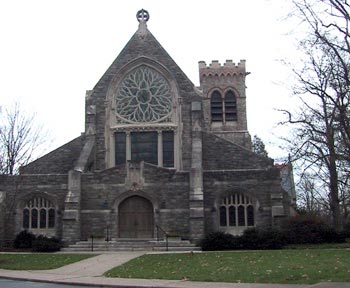
The Church of the Redeemer Episcopal Church was established in 1851 on Lancaster Avenue in Bryn Mawr, and moved to its present location in 1881. The Victorian Revival church is surrounded by the cemetery, which was begun in 1878. A Columbarium, a structure of vaults lined with recesses for cinerary urns, located in the back of the church building contains the cremated remains of a number of individuals.
Notes on compilation of the database:
In order to establish the birth and death years of those interred at the Church of the Redeemer, a visual inventory was made of the markers in the churchyard. Dates were added to the list of the plots provided by the church office.
Some stones are completely worn so that no inscriptions were discernible while others were only partly legible. Both are recorded on the new list and are noted as illegible in the comments column.
Church registers were searched for the markers of about 250 entries that could not be found. These were often unmarked graves or completely illegible stones. This number was reduced to about 150. Those dates found were added to the new list and noted “Registry Only” in the comments column. The birth year, not noted in the registers, was determined by subtracting the age of the deceased from the death year. Some birth years therefore may be incorrect by a year because days and months were not used in the calculations.
Spelling discrepancies were changed on the new list to conform with the information on the marker. Middle names and initials were added along with the dates. When only one date was on the stone, it was assumed to be the death date.
Locations in the database may be located in the cemetery using the following chart. Rows begin on the west side of the church and run parallel to New Gulph Road looking towards Fishers Road, starting with A.
| Row | Plot | To | End Stone |
|---|---|---|---|
| A | 232 | 331 | Morris |
| B | 348 | 383 | Magruder |
| C | 392 | 425 | Bankston |
| D | 438 | 473 | Strawbridge |
| E | 482 | 521 | Stroud |
| F | 526 | 569 | Cooper Crumley |
| G | 573 | 614 | Laws |
| H | 618 | 655 | Kaufman |
| I | 663 | 695 | Abel |